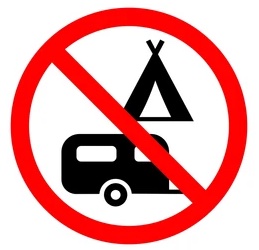
** Trail is Now Open, Bridge Remains Closed **
The damage at KM 9 will be repaired this Fall. In the meantime a detour has been set-up. The bridge at KM 13 remains closed for the season (no detour). Certains sections of the trail still require work (KM 6, 8 & 9), and we therefore recommend you use the trail with caution and walk your bike in the areas where the surface is rougher. Updated Sept. 17.
**TRAIL NOW OPEN, BRIDGE REMAINS CLOSED**
The main damage on the trail from the recent bad weather has been repaired and the trail is now open. The trail should be used with caution as some areas are still under repair.
The bridge at the Southern most end of the trail in Ogden (at KM 13) remains closed for the summer (due to the nature of the damage and the significant cost to repair it). THERE IS NO DETOUR..the surrounding roads are too dangerous so are not recommended. The bridge has little no load bearing capacity and is in danger of collapsing without warning, so SHOULD NOT BE USED at this time.
As this is a multipurpose trail, for the safety of everyone, we recommend bikes be equipped with a bell. Please respect the 20 Km/h speed limit. Thank you!
The Tomifobia Nature Trail is a multifunctional 19-km rail-trail located in the Tomifobia River valley, between Rte. 141 in Ayer’s Cliff, and Rte. 247 in Beebe (Stanstead), Quebec. It lies in the heart of the Eastern Townships’ natural and architectural heritage site. Sentiers Massawippi, a non-profit membership organization and a registered charity established in 1990, created the Tomifobia Nature Trail on an abandoned railway right-of-way, in 1993.
Open year round to bikers, hikers, joggers, snowshoers, birdwatchers, fat bikes, cross-country skiers and dogs on a leash.
Featured Photo
We would love to see your photos from the trail, if you would like to submit one, please email it to us! See more photos from the trail
Get Your Trail Membership Today!
Learn how to become a trail member and help support the trail!Trail Location
Click on the Trail Map button for a detailed map of the trail. Use it on your phone while on the trail to locate key points of interest!